
In Qatar’s journey toward becoming a leader in Smart City development, the integration of advanced engineering technologies has become a cornerstone of innovation. At ASDD Concept for Trading L.L.C., we believe that the future of urban infrastructure lies in the seamless fusion of Building Information Modeling (BIM) and Geographic Information Systems (GIS).
These two powerful tools are not separate silos—they form a continuous, data-driven workflow that enables engineers, planners, and decision-makers to build cities that are smarter, more efficient, and environmentally sustainable.
The Convergence of BIM and GIS
At their core, both BIM and GIS contribute essential intelligence to the urban lifecycle:
- BIM (Building Information Modeling) provides a detailed 3D representation of buildings, bridges, and infrastructure assets. It captures the geometry, materials, and performance data essential for design, construction, and facility management.
- GIS (Geographic Information Systems) delivers the spatial and environmental context that surrounds those assets—mapping everything from roads and utilities to land use and topography.
When BIM and GIS are integrated, they create a unified digital ecosystem that links design intent with geographical reality. This connection supports better decision-making, cost efficiency, and real-time management across all stages of development.

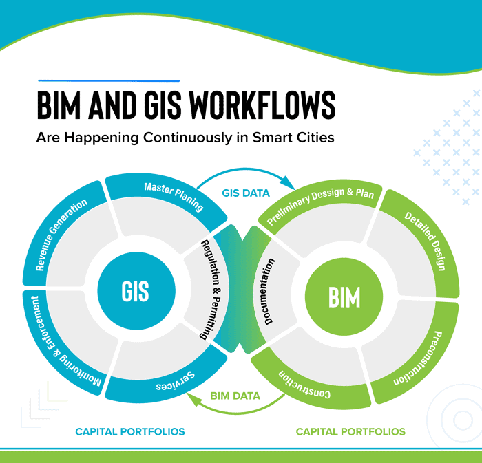
Continuous Workflows in Smart Cities
In smart city environments, BIM and GIS function as interdependent and continuous workflows that exchange data throughout planning, design, and operation.
1. GIS Workflow
GIS operates at the city-wide scale, delivering critical spatial intelligence for urban governance and infrastructure planning.
Its continuous cycle includes:
- Master Planning – Defining long-term urban strategies through spatial analytics.
- Regulation & Permitting – Aligning development with zoning, land use, and environmental policies.
- Services – Managing utility networks, roads, and transport systems.
- Monitoring & Enforcement – Tracking compliance, sustainability, and maintenance.
- Revenue Generation – Supporting land valuation, taxation, and capital asset management.
At each stage, GIS Data informs the BIM process, ensuring that design and construction reflect the realities of the physical and regulatory environment.
2. BIM Workflow
BIM takes GIS context and transforms it into detailed engineering intelligence, covering the asset-level lifecycle:
- Preliminary Design & Planning – Using GIS inputs for accurate site evaluation.
- Detailed Design – Creating high-fidelity 3D models for construction and simulation.
- Preconstruction – Integrating logistics, procurement, and scheduling data.
- Construction – Managing execution through BIM-based coordination and monitoring.
- Documentation – Producing as-built digital records that feed back into GIS systems.
This loop ensures that every change in the built environment is accurately reflected in the city’s digital ecosystem.
BIM–GIS Data Exchange: A Continuous Feedback Loop
The synergy between BIM and GIS is driven by bidirectional data exchange:
- From GIS to BIM: Environmental and spatial datasets (e.g., terrain, utilities, zoning) guide precise project planning and design.
- From BIM to GIS: Completed digital models enrich the city’s geospatial databases, updating asset information for long-term operations.
This continuous feedback loop allows for real-time analysis, predictive maintenance, and data-driven infrastructure management.
Supporting Qatar’s Smart City Vision
Qatar’s national development strategy and smart infrastructure initiatives—such as Lusail City and Msheireb Downtown—are built on principles of integration, innovation, and sustainability.
At ASDD Concept, we enable this transformation through advanced BIM and GIS integration, offering tools, training, and digital consultancy that empower engineers and organizations to achieve total project visibility and operational intelligence.
Our solutions help clients manage capital portfolios, enhance design accuracy, and accelerate digital transformation across all phases of infrastructure development.
Conclusion
The integration of BIM and GIS is redefining how cities are designed, constructed, and maintained. It ensures that every project—whether a high-rise, a transportation hub, or a public space—fits harmoniously within its larger environmental and spatial context.
For ASDD Concept, this convergence is not just a technological trend—it’s a strategic pathway toward sustainable smart cities, powered by data, driven by innovation, and guided by engineering excellence.
